Coordinates and conventions
Air showers are computed in shower coordinates, antennas sit at geodetic
positions on curved terrain and the radio emission depends on the local
geomagnetic field. grand.geo.coordinates converts between the frames
these quantities are expressed in. Mixing up frames is the most common source
of wrong results in GRANDlib and rarely raises an error, so this page states
each convention and shows it executing. Units are listed in the
cheat sheet.
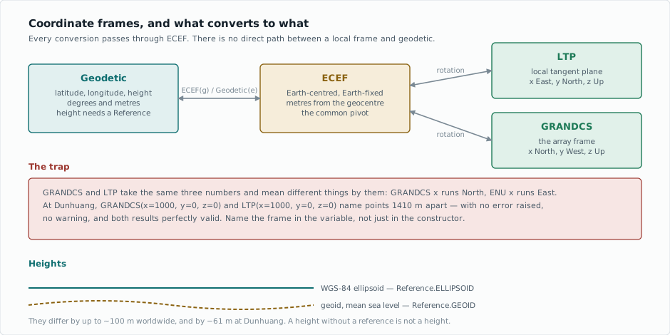
The frames
Frame |
What it is |
|---|---|
|
Latitude, longitude, height. Degrees and meters. |
|
Earth-centered, Earth-fixed Cartesian; the common pivot. |
|
Local tangent plane at a given origin and orientation. |
|
The array frame: an |
Every conversion between a local frame and geodetic passes through ECEF.
There is no direct path, so the ellipsoid constants are defined in one
place.
Converting between them
A frame is constructed from another frame by passing it to the constructor. Starting from the GRANDProto300 site at Dunhuang:
import numpy as np
from grand import Geodetic, ECEF, GRANDCS, LTP

site = Geodetic(latitude=40.98, longitude=93.95, height=1200.0)

ecef = ECEF(site)
print("ECEF (m):", np.round(np.asarray(ecef).ravel(), 1))
ECEF (m): [-332230.4 4811451.1 4161493.6]
The round trip returns the input:
back = Geodetic(ecef)
print("back to geodetic:", np.round(np.asarray(back).ravel(), 6))
back to geodetic: [ 40.98 93.95 1200. ]
A local frame needs an origin, supplied as location:
point = GRANDCS(x=1000.0, y=0.0, z=0.0, location=site)
print("1 km along GRANDCS x:", np.round(np.asarray(Geodetic(point)).ravel(), 6))
1 km along GRANDCS x: [ 40.989003 93.95006 1200.082145]
The site is at latitude 40.98, longitude 93.95. Moving 1 km along x
changed the latitude: GRANDCS x points north.
To go the other way, pass the geodetic position as the first argument:
north = Geodetic(latitude=40.99, longitude=93.95, height=1200.0)
local = GRANDCS(north, location=site)
print("0.01 deg north, in GRANDCS (m):", np.round(np.asarray(local).ravel(), 1))
0.01 deg north, in GRANDCS (m): [ 1.1107e+03 5.6000e+00 -1.0000e-01]
The point is due north, yet y is not zero: GRANDCS measures x
from magnetic north, 0.3° from geographic north at Dunhuang and z is
slightly negative because the Earth curves away below the tangent plane.
Every frame stores its components as (3, n) arrays, so a single point
comes back with shape (3, 1); np.asarray(x).ravel() flattens it to
three numbers.
Frames are NumPy arrays
Every frame subclasses numpy.ndarray, so arithmetic and broadcasting
work as for any array. Two consequences:
copy.copy()loses the origin, the basis and the height reference, which NumPy does not carry through a copy. Usegrand.geo.coordinates.copy().A component is an array, not a number.
float(position.x)works only for a single point; usenp.ravel(position.x)[0]where a number is needed.
GRANDCS and LTP axes differ
Warning
GRANDCS and LTP accept the same three numbers and mean different
things by them.
LTP with orientation='ENU' is the usual east-north-up convention, so
its x runs East. GRANDCS follows GRAND’s array convention and
its x runs North. The same triple therefore names two different
places:
grandcs = ECEF(GRANDCS(x=1000.0, y=0.0, z=0.0, location=site))
enu     = ECEF(LTP(x=1000.0, y=0.0, z=0.0, location=site,
                   orientation='ENU', magnetic=False))

separation = np.linalg.norm(np.asarray(grandcs).ravel()
                            - np.asarray(enu).ravel())
print("same numbers, different frame: %.1f m apart" % separation)
same numbers, different frame: 1410.6 m apart
Neither raises an error or a warning. A detector position mixed up this way
lands outside the array; a shower axis points at the wrong part of the
sky. Naming the frame in the variable (du_grandcs, axis_enu) makes
the mistake visible.
Orientation strings
LTP takes its axes as a three-character string, one per axis, drawn from
E/W, N/S and U/D. 'ENU' is east-north-up;
'NWU' is the GRAND convention that GRANDCS applies for you.
enu = Geodetic(LTP(x=0.0, y=1000.0, z=0.0, location=site,
                   orientation='ENU', magnetic=False))
nwu = Geodetic(LTP(x=0.0, y=1000.0, z=0.0, location=site,
                   orientation='NWU', magnetic=False))
print("1 km along y, ENU:", np.round(np.asarray(enu).ravel()[:2], 5))
print("1 km along y, NWU:", np.round(np.asarray(nwu).ravel()[:2], 5))
1 km along y, ENU: [40.989 93.95 ]
1 km along y, NWU: [40.98    93.93812]
magnetic=True measures the horizontal axes from magnetic north rather
than geographic north, using the geomagnetic model at that place and date.
The declination at Dunhuang is small, about 0.3° in 2020 by the IGRF-13
model, or roughly 50 m at the edge of a 10 km array. Elsewhere it reaches
several degrees.
Heights need a reference
A height is meaningless without saying what it is measured from. The ellipsoid is a smooth mathematical figure; the geoid is mean sea level and the two differ by up to about 100 m worldwide.
from grand.geo.coordinates import geoid_undulation

undulation = geoid_undulation(latitude=40.98, longitude=93.95)
print("geoid - ellipsoid at Dunhuang: %.2f m" % undulation)
geoid - ellipsoid at Dunhuang: -61.04 m
At Dunhuang the geoid sits 61 m below the ellipsoid, so a point 1200 m
above the ellipsoid is about 1261 m above sea level. Use
Reference to say which you mean.
Angles are in degrees
Every angle in this module (polar, azimuth, latitude, longitude, elevation) is in degrees, not radians. The representation helpers convert among Cartesian, spherical and horizontal descriptions of the same vector:
from grand.geo.coordinates import (_cartesian_to_spherical,
                                   _spherical_to_horizontal)

theta, phi, r = _cartesian_to_spherical(0.0, 0.0, 1.0)
print("straight up, spherical  : theta=%.1f deg, phi=%.1f, r=%.1f"
      % (theta, phi, r))

az, el, norm = _spherical_to_horizontal(theta, phi, r)
print("straight up, horizontal : azimuth=%.1f deg, elevation=%.1f deg"
      % (az, el))
straight up, spherical  : theta=0.0 deg, phi=0.0, r=1.0
straight up, horizontal : azimuth=90.0 deg, elevation=90.0 deg
The spherical polar angle is measured down from the zenith; elevation is measured up from the horizon. Azimuth is measured from north; the spherical \(\phi\) from the \(+x\) axis. The horizontal frame is fixed to geographic north, so converting into it assumes an ENU basis and a shared origin. Components in another Cartesian basis give a wrong azimuth without any warning.
A shower’s angles say where it comes from
A shower’s zenith and azimuth name the direction it arrives from,
not the direction it travels. A vertical shower has zenith 0°; the shower
maximum lies upstream, at those angles as seen from the core. The files
GRANDlib reads, the converters that write them and Appendix A of the GRANDlib
paper all follow this convention. _cartesian_to_spherical applied to the
position of Xmax relative to the core returns the stored zenith and azimuth;
tests/geo/test_angle_convention.py checks this against the ZHAireS
summaries of the committed example events.
Where the direction of travel is needed, negate the arrival vector.
Common mistakes
Symptom |
Cause |
|---|---|
A detector lands outside the array |
|
Positions off by tens of meters (more at sites with a larger declination) |
|
Heights off by a few meters |
Ellipsoid and geoid references mixed |
Angles wrong by a factor of about 57 |
Radians passed where degrees are expected |
Azimuth mirrored |
Spherical \(\phi\) used as an azimuth; they run in opposite senses |
A local frame refuses to convert |
No |
Note
Notebook 01, Coordinate systems (Tutorial notebooks), works through this
page with figures: a detector layout drawn in GRANDCS and in geodetic
coordinates and a shower axis in both.
Reference
Appendix A of [2] gives the transformation matrix and the
WGS-84 constants. API reference documents grand.geo.coordinates.
Where next
The data model for how positions are stored in the files.
Recipes for converting the antenna positions of a run.
Notebook 01 (Tutorial notebooks) for the frames at length, with figures.